Penn Central Track Diagrams
The following diagrams were contributed by John Donoian and Shawn O'Day. These are not official Penn Central corporate diagrams, but rather are maps that John and Shawn drew up themselves over the past several years of former PC territory. John and Shawn's goal is mapping various mainlines east of the Mississippi before rationalization by their owners (demolishing old PRR position light signals, for instance). I am grateful for their contribution of these maps, and they promise to send me many more, so here there are, and I hope that you will find these of use.
PRR (C&P) Main Line: Alliance to Cleveland, OH
The Cleveland & Pittsburgh was used by the PRR to access Cleveland from their Pittsburgh-Ft. Wayne main line. It saw a lot of coal and ore shipments to/from the docks at Whiskey Island in Cleveland. Today Norfolk Southern operates it as their Cleveland Line, and it is the main line for most traffic going from Pittsburgh to Chicago. This route holds a special place in the webmaster's heart, as it runs behind his house!
Going from south to north, starting in Alliance:
- Alliance Interlocking: Intersection of the PRR Cleveland & Pittsburgh and Pittsburgh Ft. Wayne & Chicago lines.
- Motor Yard: Walton interlocking at the north end of Motor Yard, in Walton Hills, Ohio, at MP 107.4 (distance from Rochester, PA).
- Maple Interlocking: South end of Bedford Yard in Maple Heights, Ohio, at MP 110.3.
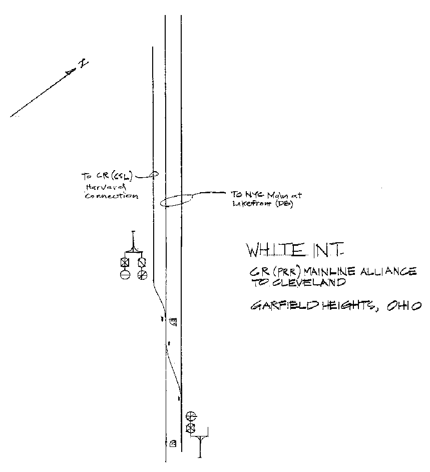
- White Interlocking: Garfield Heights, Ohio, where the Harvard Connection leaves the PRR main.
- Harvard Interlocking: The PRR, Newburgh & South Shore, and the Wheeling & Lake Erie all crossed here at MP 116.0.
- Erie Crossing: Erie's Cleveland-Youngstown line crossed the PRR at MP 116.9.
- DB Interlocking: The PRR joined the New York Central's Buffalo-Chicago main for a short distance to cross the Cuyahoga River. This is the interlocking on the east side of the river.
- DB Interlocking: Interlocking on the west side of the river, where the PRR split off to go to their docks on Lake Erie.
PRR's Toledo-Detroit Route
The PRR went from Toledo to Detroit via trackage rights on the Ann Arbor, the Chesapeake & Ohio, and it's own route north of Carleton, MI. In PC days, this line was known as the Lincoln Yard Branch. In Conrail days, it was known as the Lincoln Branch. Going from south to north:
- Manhattan Interlocking: Manhattan Tower and interlocking in Toledo, Ohio. The PRR line from Carrothers (later the Olive Secondary) crossed the Norfolk & Western (former Wheeling & Lake Erie) here.
- AA Ottawa Yard: Ann Arbor's Ottawa Yard in Toledo. The PRR (later PC) had trackage rights on the Ann Arbor north out of Toledo.
- AA Ottawa Yard Throat: Detail of the south yard throat of Ann Arbor's Ottawa Yard and Boulevard Interlocking in Toledo, Ohio, where the PRR crossed the Toledo Terminal's line to their Cherry St. Station and joined the AA.
- Hallett Interlocking: Interlocking at Hallett Tower, where the PRR/AA and the Chesapeake & Ohio crossed the Toledo Terminal. Hallett Tower still stands today.
- Alexis Interlocking: Interlocking at Alexis Tower, where the PRR/AA and the C&O crossed the ex-New York Central line from Toledo to Detroit (Toledo Branch). This tower no longer stands today.
- Monroe, MI: Monroe, Michigan, where the C&O (with PRR trackage rights) crossed an ex-New York Central branch line.
- Carleton, MI: Carleton, Michigan, where the PRR left the C&O's trackage rights after crossing the Detroit Toledo & Ironton's main line from Diann to Flat Rock.
- Brownstown Township, MI: Brownstown Township, Michigan, where the PRR had a yard that served a Ford Motor Company parts distribution plant.
- Penford Interlocking: Taylor, MI, where the PRR crossed DT&I's Dearborn Branch, protected by a tower.
- Delray Interlocking, continued: Delray Interlocking, continuation A from above. Includes drawbridge over the Rouge River and the PRR Foreman Wye, which leads to Rougemere Yard on the C&O.
- Delray Interlocking: Delray Interlocking in Detroit, MI, where just about everybody crossed. The N&W, C&O, PRR, NYC, and Detroit & Toledo Shore Line (later Grand Trunk Western) all crossed here.
- Rougemere Yard: Rougemere Yard in Detroit/Dearborn, MI. At the north end of the line.
Panhandle (PRR) Main, Pittsburgh to Columbus
This group of maps covers some points of interest in central Ohio on the former PRR main between Pittsburgh and Columbus. Today the line is operated by the Columbus & Ohio River, a part of the Ohio Central System. Starting on the east side of Newcomerstown (MP 108 from Pittsburgh) and going west:
- Newcomerstown East: Two industrial customers were served at Newcomerstown.
- Newcomerstown, Ohio: In downtown Newcomerstown, the Panhandle crossed the former PRR Dover Secondary which ran from Bayard (on the C&P) to Marietta, on the Ohio River. The name of the interlocking was TOWN in PC days, and was located at MP 108.2.
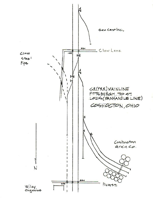
- Coshocton west: At Coshocton, Ohio, the line served a couple of customers.
- Newark, Ohio: This shows trackage just east of the junction with the B&O and the start of the joint trackage into Columbus. Two industries were served here.
Panhandle (PRR) Main, Columbus to Chicago
Chicago Union Station to 12th Street, Chicago
This series of diagrams covers the former joint Milwaukee Road passenger main/PRR main coming north and west out of Chicago Union Station between C.U.S. and 12th Street. This line was part of the Panhandle main line from Columbus, Ohio, to Chicago. Working out from Union Station (warning: these maps are large):
- Union Station: Coming out the north side of Union Station, passing the MILW freight house and going under the Chicago & North Western. Union Station was at MP 314.1 (from Columbus) on the ex-PRR.
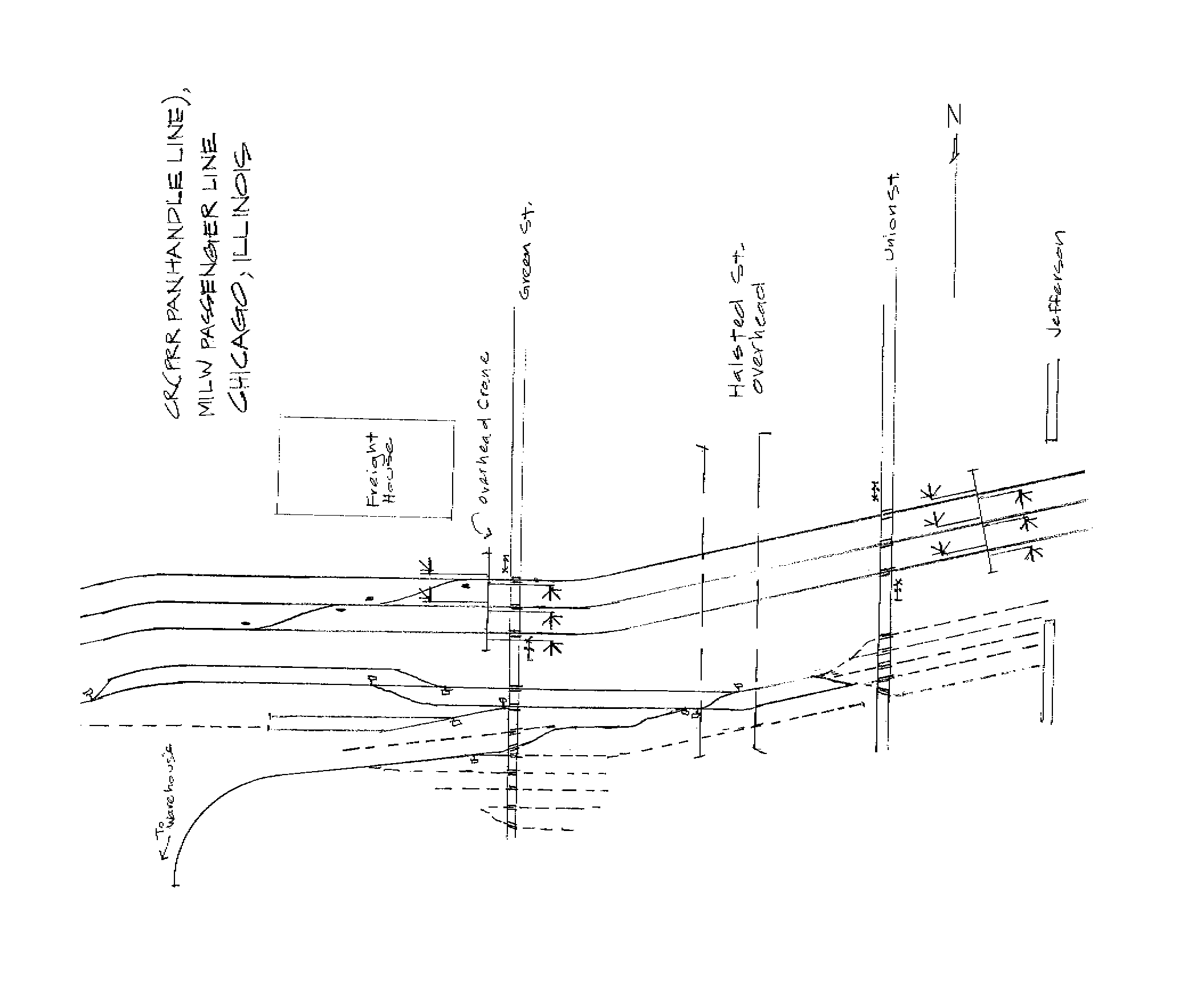
- Jefferson to Green Street: Crossing Jefferson Street, Union Street, passing under Halsted Street, and crossing Green St.
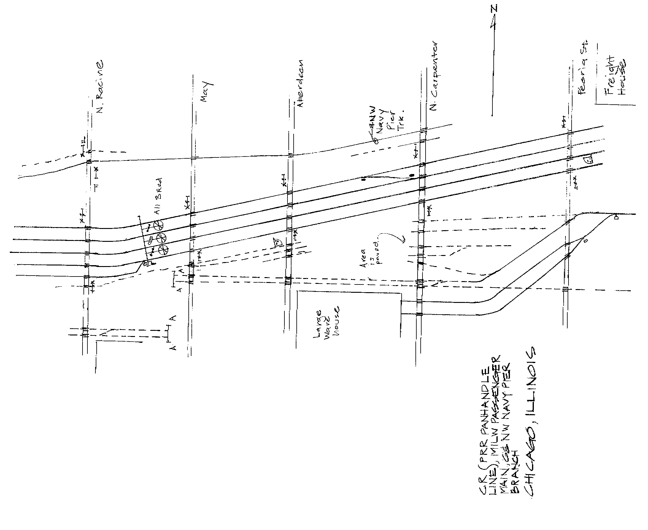
- Peoria St. to N. Racine St.: The C&NW Navy Pier Branch parallels the main here. Today, the Navy Pier Branch is still used by UP and runs under skyscapers (IBM and a hotel) to reach the Sun-Times printing press operation.
- Ogden Ave.: The C&NW main line begins to follow the PRR/MILW main, and the Navy Pier branch joins the C&NW main.
- Wolcott St. to Oakley Ave.: Crossing over top of Damen St., Hoyne Ave., and N. Leavitt St.
- Western Avenue Interlocking: The Milwaukee Road passenger splits off here, and two C&NW mains join in an wye. This was at MP 311.6 on the ex-PRR.
- 12th Street Interlocking: At MP 309.9 the PRR crossed the C&NW main line, the B&O Chicago Terminal main line, and the B&OCT Altenheim Subdivision.
North Judson, Indiana
- North Judson Interlocking: The Panhandle main crossed the ex-NYC Kankakee Branch, the Chesapeake & Ohio's Wabash Subdivision, and the Erie Lackawanna's main line to Chicago. Only the C&O remains here today.
Grand Rapids & Indiana Branch (PRR)
The GR&I Branch ran from Mackinaw City, at the northernmost tip of lower Michigan, south through Grand Rapids and Kalamazoo to Fort Wayne, Indiana.
Grand Rapids, Michigan
- Fuller Interlocking: The ex-PRR GR&I crossed the C&O Grand Rapids Terminal Subdivision and the Grand Trunk Western main line here in Grand Rapids. The GR&I is gone today.
Canada Southern (CASO) main line, Detroit-Buffalo
These two diagrams were drawn and contributed by Adrian Telizyn.
- Windsor, Ontario: CTC diagram of Windsor, including connection to Canadian Pacific.
- Welland, Ontario: Drawing of Welland, showing joint PC/Toronto Hamilton & Buffalo facilities.